


 Landscape photography has brought an incredible amount of discovery to my life. It has fueled a passion for further exploration of the beauty of grandeur of landscapes I have yet to experience. While having great luck living in the beautiful state of Colorado, I am always drawn to the diverse beauty of Oregon. From the waterfalls of the Columbia River Gorge, beautiful mountain lakes, and the rugged Pacific coast with its famous lighthouses, I am always dreaming of my next trip to discover and experience more of Oregon.
My emotional favorite area in Oregon has to be the Columbia River Gorge, an area that is rich in history and significance in the growth of the Pacific Northwest. For more than 13,000 years, Indian People flourished here thriving on abundant runs of salmon and steelhead. And, as is the case today in our modern economy, for thousands of years the Columbia River Gorge has been the economic pathway connecting the Pacific Northwest with the rest of the continent.
The natural story of the gorge’s formation is also the story behind the numerous lush waterfalls to be experienced here. Over the centuries, the fiery volcanoes of the Cascade Mountain Range left lava and mudflows up to two miles thick through which the Columbia River cut a deep canyon.
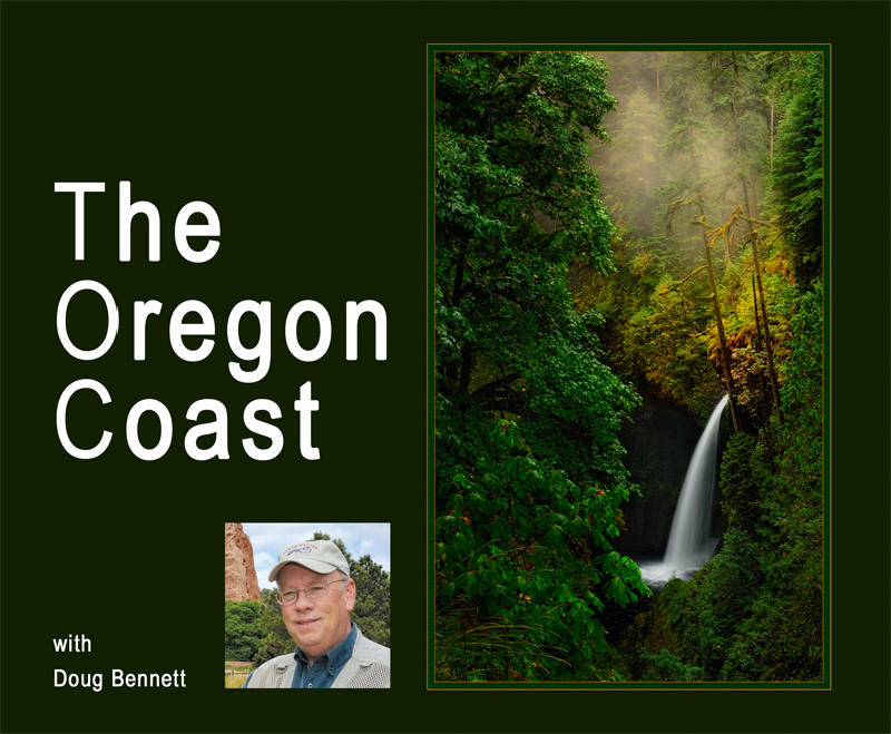
The greatest force in the Gorge’s creation came 15,000 years ago near the end of the last Ice Age. Gigantic floods up to 1,200 feet deep swept down the river scouring its cliffs. This left tributary streams draining snowmelt from nearby Mt. Hood hanging high above the river’s bed. This leaves us today with one of the world’s greatest concentration of waterfalls. Which bring us to the image titled “Eden’s First Light” (on the front cover of this magazine).
While most everyone is familiar with Multnomah Falls that one can easily see from I-94 east of Portland and which is certainly impressive, when I first saw Metlako Falls, I immediately had the sensation that this must have been what Eden looked like, thus the title “Eden’s First Light.”
Metlako Falls is the furthest downstream waterfall of the major waterfalls on Eagle Creek and as a result, it is the upstream limit for salmon spawning in Eagle Creek. It is located off a short trail spur two miles in from the parking lot near the Old Columbia Gorge highway. The 101 foot tall waterfall was discovered in 1915 and named after Metlako, the Indian goddess of salmon.
Metlako Falls was instrumental in my growth in landscape photography. When I captured the image in 2010, I was just beginning to dabble in PPA competition. I worked this image and entered it into three photography shows in the Colorado area and the results were beyond my wildest hopes. The image scored two Best of Shows and a First Place. Most happily, I pocketed $1,800 in awards monies!
So, I thought “Eden’s First Light” would be an obvious entry for me in PPA print competition, surely a Merit, and hopefully a Loan Print. When it didn’t merit in 2012, I was surprised and thought maybe I just had a juror panel that was getting hungry or something. So I entered it again the following year in SWPPA District with essentially no changes and again no merit. But (and this is a big BUT) this time I ordered a video critique.
 When I watched the video critique, I was thinking, “Yeah, maybe…” to the comments being offered. Prior to entering the 2013 IPC, I decided to implement all those “yeah maybes” on the image. When I finished, I loved what was before me on the screen and could no longer stand to gaze upon my earlier version that had put so much money in my pocket. You can probably guess the rest of the story… in the 2013 IPC “Eden’s First Light” merited and then went Loan.
Since that time, I have been sold on print competition and getting those video critiques. What’s more, print competition convinced me there was still so much more to learn and that learning never ends. At TPPA Summerfest, I will be sharing all that I have learned and more in my presentation on Landscape Photography. Now back to Oregon.
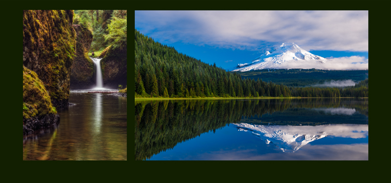
From the Metlako Falls overlook, 1/4th mile further up the trail is Punch Bowl Falls. This falls ranks with Mount Hood, Multnomah Falls, and Crater Lake as enduring icons of Oregon and the beauty of the Pacific Northwest. As evidenced by its name, the falls has carved a deep, bowl-shaped pool at the base of the fall. In fact, geologists have borrowed the name “Punch Bowl” as a new type-designation for other waterfalls with the same basic flow. Metlako Falls is also classified as a punch bowl waterfalls.
Sadly, as I began my research on these two waterfalls on Eagle Creek for this article, I learned of two very astonishing events. First, in January 2017, very heavy rains resulted in the overlook at Metlako Falls (from which I captured my image) collapsing into the gorge hundreds of feet below. Now, there is no safe spot from which to view Metlako Falls.
Then in September 2017, a 15 year old boy playing with fireworks along the Eagle Creek Trail resulted in the devastating Eagle Creek Fire which burned for three months consuming almost 50,000 acres. This fire severely damaged the Eagle Creek Trail and it is now closed until repairs can be made. Hopes are the trail will be opened in Summer 2018 and my hopes are it will include a new overlook for Metlako Falls.
Driving east on I-94 from the Eagle Creek Trailhead, you can turn to the south on Hwy 35 leading towards Bend, Oregon. Near the junction with U.S. Hwy 26, is Trillium Lake. This magnificent location is situated 7.5 miles south-southwest of Mount Hood and is formed by a dam at the headwaters of Mud Creek.
The area, which is covered by the lake, was part of the Barlow Road, a component of the Oregon Trail. This road was an option to taking the perilous trip down the Columbia River for the early immigrants striving to reach the fertile valleys to the west. This part of the Barlow Road was a log road across marshes allowing the immigrants to reach Summit Meadow, the toll station for this route to the west between 1866 and 1870.
For photographers, the shallow depth of the lake often provides a mirror like surface to photograph the reflection of Mount Hood when it isn’t shrouded in clouds. The morning I was there, landscape shooters from Portland were ecstatic with the shooting conditions. I felt very lucky to have been there at the right time. Of course being a landscape photographer, I wished I had been there earlier and that dramatic sunrise clouds and light had been present.
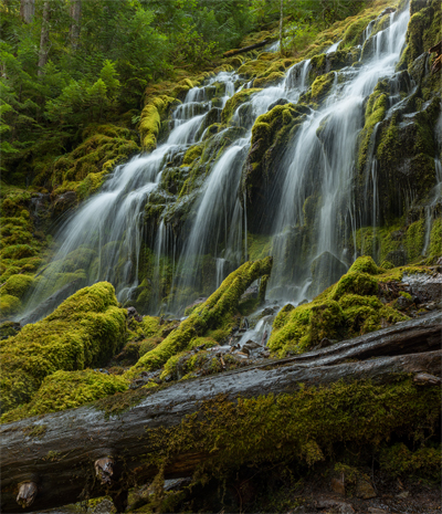
West of Bend, Oregon, is one of the most amazing waterfalls in Oregon, if not the Pacific Northwest. It is Proxy Falls. The size is unbelievable especially when you are standing right underneath it, which is not that difficult. The falls is fed by one stream cascading into two separate shimmering veils dropping 226 feet. Uniquely, the water at the foot of the falls largely disappears as it sinks through the porous lava into the ground.
The trail assessing the falls is an easy two mile round trip. At the base of the falls, one has to be very careful as the spray causes slippery rocks and logs. You also have to make sure your camera is ready for the spray (such as a rain sleeve) and be sure to have a lens cloth. Preferred times to shoot the falls are in the morning or afternoon because the sunrays shine through the tall trees and light up the misty water coming off the falls.
The trailhead for Proxy Falls is located along Hwy 242 west of Bend (which in itself is a fabulously scenic drive) and is closed during winter. Fall is generally the best time for photography with fall colors, less weather variations, and fewer people. Early spring, once the road opens, is also a great time to photograph as the water flow is higher, spring flowers are blooming, and there are fewer people.
Sparks Lake, 25 miles west of Bend off the Cascade Lakes Scenic Byway, is said to be “so beautiful, it doesn’t need to be interesting.” Without question, it is both beautiful and interesting.
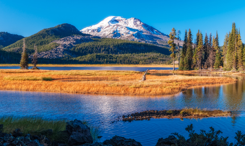
For us landscape photographers, Sparks Lake is what we dream about. Comprising 370 acres of lake wetland surrounded by another 360 acres of meadow, marsh, and stream wetlands, this spectacular setting, – a memorialized favorite of the late, acclaimed, landscape photographer Ray Atkeson – is dominated by three volcanic peaks (South Sister at 10,358 ft, Broken Top at 9,175 ft, and Mount Bachelor at 9,065 ft) rising in dramatic splendor above the crystal waters of the lake.
When Mount Bachelor erupted 10,000 years ago, it formed a lava dam that began capturing snowmelt and rainwater to become Sparks Lake. But cracks in the volcanic rock below the lake means the lake is gradually draining water through the summer. In some of the smaller coves along the shoreline, one can actually hear the water gurgling below as the water filters out of the lake. Having no other water outlets, the water enters a subterranean system of groundwater that connects just about everything in this region of Central Oregon. The water filters into other creeks eventually becoming the source of the Deschutes River.
One can easily spend two days photographing around Sparks Lake as there are trails all about the lake with great compositions to be had in any direction you choose. The Oregon Coastline extends over 360 miles with rich photographing opportunities than could easily fill a book. While I have yet to visit all the coastal opportunities, one which simply astounded me was Cape Kiwanda.
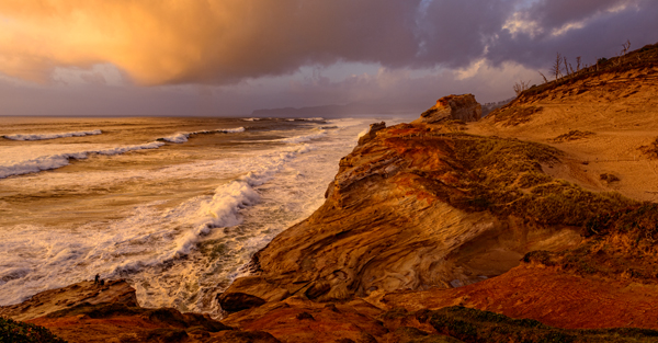
Cape Kiwanda State Natural Area is a state park in Pacific City, Oregon, and is a part of the Three Capes Scenic Route which includes Cape Meares and Cape Lookout.
One of the dazzling features of Cape Kiwanda is its brilliant sandstone reminding me of the Canyonlands of Utah. Offshore is the monolith that has protected the soft strata of the Cape from being extinguished by ocean weather. It is the “other” Haystack Rock, a classic basalt sea stack not to be confused with the more widely known Haystack Rock at Cannon Beach.
Behind the Cape is the Great Dune, a massive hill of mudstone and sandstone layers cloaked in drifting sand.
From the parking lot, you can hike up the sand dune to the north to the crest of the Cape to get a commanding view. The waves of the Pacific breaking below are some of the most vigorous breakers to be found along the Oregon coast. Composed with the brilliant sandstone provides images with astounding beauty and impact. As you ascend the sandstone and reach the crest of the Cape, you will see fence lines protecting sensitive areas as well as you! The fence protects you from soft cliff edges that can fall away into deep coves at any time. In fact, seven people have died falling into the ocean and onto the rocks since 2009.
Once you are on the Cape’s crest above the sand dune, you will see that you are able to negotiate your way down to the land bridge that connects the Cape to a large flat topped stack jutting further west into the ocean. It is very high and one can readily think it is safe to climb up to the top of the stack. But due to some uniqueness of the shoreline on the west side of the stack that cannot be seen, waves can be vastly magnified in height and volume and actually crest and sweep across the top of the stack and then cascade down the eastern side of the stack. See the accompanying photo to see this wave in action. This only occurs when conditions are right but the afternoon/evening I was there I saw it happen five times. I finally set up my camera and dialed in an exposure to make sure I captured the phenomena the next time it happened. I finally got the shot after a wait of around 20 minutes.
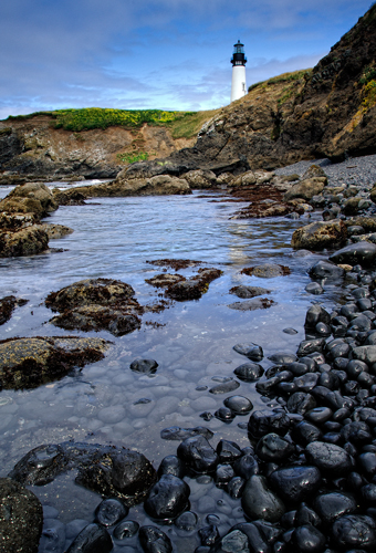
One of the highlights of the Oregon coast is one hour south of Cape Kiwanda. The Yaquina Head Lighthouse located on the north edge of the coastal city Newport, is 93 ft tall making it the tallest on the Oregon coast. The lighthouse is located on a narrow strip of basalt emanating from an ancient volcanic flow that juts one mile westward into the Pacific.
Made in Paris in 1868 and shipped to Oregon, Yaquina Head Light was first lit August 20, 1873, after a year and 370,000 bricks to build the lighthouse. At that time, the oil burning fixed white light burned from sunset to sunrise. The oil burning wicks have now been replaced with a 1000 watt globe.
The lighthouse was automated in 1966 and is still active today. During WWII, 17 servicemen were stationed at Yaquina Head to keep a lookout for enemy ships. The lighthouse still uses its original 1868 French-made Fixed Fresnel lens. It is visible 19 miles out to sea.
With the lighthouse being located on this basalt outcropping, there are numerous compositions to be had. I love shooting from down at the ocean’s edge getting very low to the smoothed basalt rocks to include them in the foreground.
I have made three trips to Oregon over the last decade and yet I feel I have only scratched the surface. I look forward to returning to the Columbia River Gorge trails once they reopen to capture the rebirth of the ecosystem which have the potential to giving a much different look to the waterfalls there. I want to shoot at Bandon Beach and spend more time at Sparks Lake. And lastly, I haven’t even mentioned the fantastic seafood to be had.
Personally, I can’t wait! Who is ready to go? See you at Summerfest!
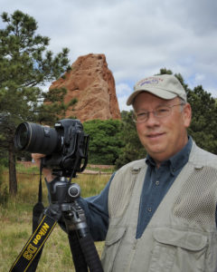 Doug Bennett lives in Colorado Springs, Colorado, and is a retired Air Force officer. He and his wife, Laura, enjoy travel, landscape photography, and selling their art in art shows and to corporate clients. Doug will present a program, “Landscape Photography: Craft & Technique, Art & Expression,” at Summerfest 2018.


